

Places to go
 Playgrounds108 playgrounds · nearest 0.3 miNearest first →
 Libraries22 libraries · nearest 0.4 miOpening hours →
 Schools42 primary · 34 secondary or otherWith Ofsted results →Playgrounds in HarrowUpdated 3 days ago · OpenStreetMap×
- 0.6 miHeadstone Manor Play AreaPlaygroundOpenStreetMap →
- 0.8 miPerceval Square Play AreaPlaygroundOpenStreetMap →
- 1.2 miCourtyardPlaygroundOpenStreetMap →
- 1.8 miCentenary Play ParkPlaygroundOpenStreetMap →
- 1.9 miRoxbourne PlaygroundPlaygroundWheelchair accessibleOpenStreetMap →
- 2.3 miWood End East Recreation Ground PlaygroundPlaygroundOpenStreetMap →
- 2.6 miLindsay Park playgroundPlaygroundOpenStreetMap →
- 2.7 miPine Gardens PlaygroundPlaygroundOpenStreetMap →
- 3.1 miCarr Road PlaygroundPlaygroundOpenStreetMap →
- 3.3 miVictoria Road Children's PlaygroundPlaygroundOpenStreetMap →
- 3.4 miStonefield Park Childrens PlaygroundPlaygroundOpenStreetMap →
- 3.8 miTrevor Crescent Childrens PlaygroundPlaygroundOpenStreetMap →
Nothing matches.
Plus 96 smaller playgrounds without a name on the map data.
Libraries in HarrowUpdated 3 days ago · OpenStreetMap×- 0.4 miHarrow Reference LibraryLibraryOpenStreetMap →
- 0.5 miWealdstone LibraryLibraryWheelchair accessibleOpenStreetMap →
- 0.8 miGreenhill LibraryLibrary · Mo-Sa 10:00-18:00; Su 11:00-15:00OpenStreetMap →
- 0.8 miNorth Harrow Community LibraryLibrary · Tu,Th,Sa 10:00-17:00OpenStreetMap →
- 1.2 miLibraryLibraryOpenStreetMap →
- 1.4 miKenton LibraryLibraryOpenStreetMap →
- 1.6 miPinner LibraryLibraryOpenStreetMap →
- 2.0 miRoxeth LibraryLibraryWheelchair accessibleOpenStreetMap →
- 2.4 miStanmore public libraryLibraryOpenStreetMap →
- 2.5 miEastcote LibraryLibraryOpenStreetMap →
- 2.6 miWood End Library & Children's CentreLibraryOpenStreetMap →
- 2.9 miKingsbury Library PlusLibraryWheelchair accessibleOpenStreetMap →
- 2.9 miNorthwood Hills LibraryLibraryOpenStreetMap →
- 3.0 miBarham Park LibraryLibraryOpenStreetMap →
- 3.0 miNortholt Leisure Centre LibraryLibraryOpenStreetMap →
- 3.2 miSouth Ruislip LibraryLibraryOpenStreetMap →
- 3.2 miRuislip Manor LibraryLibrary · Mo,We 09:00-19:00; Tu,Th-Sa 09:00-17:00OpenStreetMap →
- 3.3 miUCL Institute of Orthopaedics LibraryLibraryOpenStreetMap →
- 3.3 miNorthwood LibraryLibraryOpenStreetMap →
- 3.4 miEaling Road LibraryLibraryOpenStreetMap →
- 3.4 miWembley LibraryLibrary · Mo-Fr 08:00-20:00; Sa-Su 10:00-17:00OpenStreetMap →
- 3.5 miEdgware LibraryLibraryWheelchair accessibleOpenStreetMap →
Nothing matches.
Schools in HarrowUpdated 3 days ago · DfE and Ofsted×- GoodMarlborough Primary SchoolPrimary · ages 3–11 · 651 pupils · HA1 1UJ · 0.1 miOfsted: Good · Oct 2023Ofsted report →Website
- GoodNorbury SchoolPrimary · ages 3–11 · 641 pupils · HA1 1QQ · 0.5 miOfsted: School remains Good · Mar 2023Ofsted report →Website
- Not yet inspectedAlpha Preparatory Schoolages 3–11 · 110 pupils · HA1 1SH · 0.5 miNot yet inspected by OfstedWebsite
- GoodWhitefriars SchoolAll-through · ages 3–18 · 1,419 pupils · HA3 5RQ · 0.5 miOfsted: Good · Mar 2024Ofsted report →Website
- GoodSaint Jerome Church of England Bilingual SchoolPrimary · Church of England · ages 4–11 · 408 pupils · HA1 2DJ · 0.6 miOfsted: Good · Nov 2022Faith school: Church of EnglandOfsted report →Website
- Not yet inspectedHarrow Collegiateages 16–19 · HA3 5PQ · 0.6 miNot yet inspected by Ofsted
- Report cardSalvatorian Roman Catholic CollegeSecondary · Roman Catholic · ages 11–16 · 802 pupils · HA3 5DY · 0.7 miOfsted report card · Sept 2026Safeguarding standards: MetInclusion: StrongCurriculum and teaching: StrongAchievement: StrongAttendance and behaviour: ExceptionalPersonal development and wellbeing: StrongPost-16 provision (where applicable): StrongLeadership and governance: StrongFaith school: Roman CatholicOfsted report →Website
- Not yet inspectedThe Sacred Heart Language CollegeSecondary · Roman Catholic · ages 11–16 · 714 pupils · HA3 7AY · 0.7 miNot yet inspected by OfstedFaith school: Roman CatholicOfsted report →Website
- OutstandingThe Jubilee Academyages 11–16 · HA1 3AW · 0.8 miOfsted: Outstanding · Apr 2023Ofsted report →Website
- GoodPinner Park Primary SchoolPrimary · ages 3–11 · 858 pupils · HA5 5TL · 0.8 miOfsted: Good · Mar 2024Ofsted report →Website
- Report cardVaughan Primary SchoolPrimary · ages 3–11 · 668 pupils · HA1 4EL · 0.9 miOfsted report card · Sept 2026Safeguarding standards: MetInclusion: StrongCurriculum and teaching: ExpectedAchievement: StrongAttendance and behaviour: StrongPersonal development and wellbeing: ExpectedEarly years (where applicable): ExpectedLeadership and governance: ExpectedOfsted report →Website
- GoodElmgrove Primary School & NurseryPrimary · ages 3–11 · 805 pupils · HA3 8LU · 0.9 miOfsted: Good · Sept 2023Ofsted report →Website
- OutstandingNower Hill High SchoolSecondary · ages 11–18 · 2,030 pupils · HA5 5RP · 0.9 miOfsted: Outstanding · Nov 2023Ofsted report →Website
- GoodBelmont SchoolPrimary · ages 3–11 · 658 pupils · HA3 7JT · 0.9 miOfsted: Good · Mar 2024Ofsted report →Website
- GoodHarrow High SchoolSecondary · ages 11–18 · 982 pupils · HA1 2JG · 1.0 miOfsted: School remains Good · Sept 2023Ofsted report →Website
- Not yet inspectedHeartwood Houseages 11–17 · 60 pupils · HA1 2BW · 1.0 miNot yet inspected by OfstedWebsite
- OutstandingSt Anselm's Catholic Primary SchoolPrimary · Roman Catholic · ages 4–11 · 408 pupils · HA1 3BE · 1.0 miOfsted: Outstanding · Feb 2024Faith school: Roman CatholicOfsted report →Website
- Not yet inspectedHarmony Primary Schoolages 5–11 · 60 pupils · HA1 2LS · 1.1 miNot yet inspected by OfstedWebsite
- GoodCedars Manor SchoolPrimary · ages 3–11 · 339 pupils · HA3 6LS · 1.1 miOfsted: School remains Good · Oct 2019Ofsted report →Website
- GoodSt Teresa's Catholic Primary School and NurseryPrimary · Roman Catholic · ages 3–11 · 428 pupils · HA3 6LE · 1.1 miOfsted: School remains Good · Sept 2023Faith school: Roman CatholicOfsted report →Website
- OutstandingShaftesbury High Schoolages 11–19 · 165 pupils · HA3 6LE · 1.1 miOfsted: School remains Outstanding (Concerns) - S5 Next · Sept 2019Ofsted report →Website
- OutstandingSt John Fisher Catholic Primary SchoolPrimary · Roman Catholic · ages 4–11 · 628 pupils · HA5 5RA · 1.2 miOfsted: Outstanding · Dec 2023Faith school: Roman CatholicOfsted report →Website
- GoodSt Joseph's Catholic Primary SchoolPrimary · Roman Catholic · ages 3–11 · 447 pupils · HA3 7LP · 1.2 miOfsted: Good · Mar 2024Faith school: Roman CatholicOfsted report →Website
- OutstandingKingsley High Schoolages 11–19 · 134 pupils · HA3 6ND · 1.2 miOfsted: School remains Outstanding · Jan 2024Ofsted report →Website
- GoodHatch End High SchoolSecondary · ages 11–18 · 1,226 pupils · HA3 6NR · 1.2 miOfsted: School remains Good · Feb 2024Ofsted report →Website
- Not yet inspectedWhitmore High SchoolSecondary · ages 11–18 · 1,724 pupils · HA2 0AD · 1.3 miNot yet inspected by OfstedOfsted report →Website
- Not yet inspectedHarrow SchoolChurch of England · ages 12–19 · 833 pupils · HA1 3HP · 1.3 miNot yet inspected by OfstedFaith school: Church of EnglandWebsite
- OutstandingPriestmead Primary School and NurseryPrimary · ages 2–11 · 877 pupils · HA3 8SZ · 1.3 miOfsted: Outstanding · Dec 2023Ofsted report →Website
- GoodWeald Rise Primary SchoolPrimary · ages 2–11 · 361 pupils · HA3 7DH · 1.3 miOfsted: School remains Good · May 2023Ofsted report →Website
- Not yet inspectedThe John Lyon Schoolages 2–18 · 781 pupils · HA2 0HN · 1.3 miNot yet inspected by OfstedWebsite
- GoodLongfield Primary SchoolPrimary · ages 3–11 · 617 pupils · HA2 7NZ · 1.3 miOfsted: Good · Jul 2023Ofsted report →Website
- GoodGrange Primary SchoolPrimary · ages 3–11 · 443 pupils · HA2 0RY · 1.4 miOfsted: Good · Apr 2023Ofsted report →Website
- Not yet inspectedBuckingham Preparatory Schoolages 2–11 · 103 pupils · HA5 5DT · 1.4 miNot yet inspected by OfstedWebsite
- Not yet inspectedRoxeth Primary SchoolPrimary · ages 4–11 · 402 pupils · HA2 0JA · 1.4 miNot yet inspected by OfstedOfsted report →Website
- Not yet inspectedReddiford SchoolChurch of England · ages 2–11 · 195 pupils · HA5 5HH · 1.5 miNot yet inspected by OfstedFaith school: Church of EnglandWebsite
- UngradedHillview Nursery SchoolNursery · ages 2–5 · 71 pupils · HA2 0LW · 1.6 miOfsted: Standards maintained · Jun 2025Ofsted report →Website
- GoodThe Helix Education Centreages 5–16 · 46 pupils · HA3 6DH · 1.6 miOfsted: School remains Good (Concerns) - S5 Next · Nov 2023Ofsted report →Website
- GoodHujjat Primary SchoolPrimary · Muslim · ages 4–11 · 356 pupils · HA3 6RR · 1.6 miOfsted: Good · Jan 2023Faith school: MuslimOfsted report →Website
- Not yet inspectedSt Dominic's Sixth Form College16 plus · Roman Catholic · ages 16–18 · HA1 3HX · 1.6 miNot yet inspected by OfstedFaith school: Roman CatholicWebsite
- Not yet inspectedRise Collegeages 16–25 · HA2 0XH · 1.7 miNot yet inspected by OfstedWebsite
- Report cardStanburn Primary SchoolPrimary · ages 3–11 · 694 pupils · HA7 2PJ · 1.9 miOfsted report card · Sept 2026Safeguarding standards: MetInclusion: StrongCurriculum and teaching: ExpectedAchievement: StrongAttendance and behaviour: ExpectedPersonal development and wellbeing: StrongEarly years (where applicable): StrongLeadership and governance: StrongOfsted report →Website
- Not yet inspectedPark High SchoolSecondary · ages 11–18 · 1,475 pupils · HA7 1PL · 1.9 miNot yet inspected by OfstedOfsted report →Website
- Not yet inspectedOrley Farm Schoolages 4–13 · 467 pupils · HA1 3NU · 1.9 miNot yet inspected by OfstedWebsite
- GoodWest Lodge Primary SchoolPrimary · ages 4–11 · 642 pupils · HA5 1AF · 1.9 miOfsted: Good · Mar 2023Ofsted report →Website
- OutstandingBentley Wood High SchoolSecondary · ages 11–18 · 1,393 pupils · HA7 3JW · 1.9 miOfsted: Outstanding · Nov 2023Ofsted report →Website
- OutstandingSt George's Primary Catholic Voluntary AcademyPrimary · Roman Catholic · ages 2–11 · 404 pupils · HA1 3SB · 1.9 miOfsted: Outstanding · Jul 2023Faith school: Roman CatholicOfsted report →Website
- UngradedAlexandra Schoolages 4–11 · 99 pupils · HA2 9DX · 2.0 miOfsted: Standards maintained · Apr 2025Ofsted report →Website
- GoodNewton Farm Nursery, Infant and Junior SchoolPrimary · ages 3–11 · 462 pupils · HA2 9JU · 2.0 miOfsted: Good · Sept 2022Ofsted report →Website
- GoodKenmore Park Junior SchoolPrimary · ages 7–11 · 321 pupils · HA3 9JA · 2.0 miOfsted: School remains Good · Feb 2023Ofsted report →Website
- GoodKenmore Park Infant and Nursery SchoolPrimary · ages 3–7 · 278 pupils · HA3 9JA · 2.0 miOfsted: Good · Nov 2023Ofsted report →Website
- Requires improvementGlebe Primary SchoolPrimary · ages 3–11 · 566 pupils · HA3 9LF · 2.0 miOfsted: Requires improvement · Oct 2023Ofsted report →Website
- GoodCannon Lane Primary SchoolPrimary · ages 4–11 · 712 pupils · HA5 1TS · 2.0 miOfsted: School remains Good (Improving) - S5 Next · Oct 2023Ofsted report →Website
- Not yet inspectedGesher Schoolages 4–16 · 80 pupils · HA5 1JF · 2.1 miNot yet inspected by OfstedWebsite
- UngradedPinner High SchoolSecondary · ages 11–18 · 1,111 pupils · HA5 1NB · 2.1 miOfsted: Standards maintained · Mar 2025Ofsted report →Website
- GoodThe Welldon Park AcademyPrimary · ages 3–11 · 420 pupils · HA2 8LS · 2.1 miOfsted: Good · Jun 2023Ofsted report →Website
- OutstandingGrimsdyke SchoolPrimary · ages 4–11 · 625 pupils · HA5 4QE · 2.1 miOfsted: Outstanding · Nov 2023Ofsted report →Website
- GoodWhitchurch Primary School & NurseryPrimary · ages 3–11 · 797 pupils · HA7 2EQ · 2.1 miOfsted: School remains Good · Sept 2023Ofsted report →Website
- GoodAvanti House SchoolSecondary · Hindu · ages 11–18 · 1,206 pupils · HA7 2EQ · 2.1 miOfsted: School remains Good (Improving) - S5 Next · Oct 2023Faith school: HinduOfsted report →Website
- Not yet inspectedStanmore College16 plus · ages 16–99 · HA7 4BQ · 2.1 miNot yet inspected by OfstedWebsite
- Not yet inspectedPathways Schoolages 11–19 · 16 pupils · HA3 9LX · 2.1 miNot yet inspected by OfstedWebsite
- GoodHeathland SchoolPrimary · ages 3–11 · 656 pupils · HA2 9AG · 2.2 miOfsted: Good · Sept 2023Ofsted report →Website
- UngradedRoxbourne Primary SchoolPrimary · ages 3–11 · 465 pupils · HA2 9QF · 2.3 miOfsted: Improved significantly · Jun 2025Ofsted report →Website
- Not yet inspectedLD Training Services LimitedHA7 1FW · 2.3 miNot yet inspected by OfstedWebsite
- Not yet inspectedSt Bernadette's Catholic Primary SchoolPrimary · Roman Catholic · ages 3–11 · 448 pupils · HA3 9NS · 2.3 miNot yet inspected by OfstedFaith school: Roman CatholicOfsted report →Website
- GoodRooks Heath SchoolSecondary · ages 11–18 · 1,148 pupils · HA2 9AH · 2.3 miOfsted: School remains Good · Mar 2024Ofsted report →Website
- GoodSt John's CofE SchoolPrimary · Church of England · ages 2–11 · 278 pupils · HA7 3FD · 2.4 miOfsted: School remains Good · Jul 2024Faith school: Church of EnglandOfsted report →Website
- OutstandingPinner Wood SchoolPrimary · ages 3–11 · 681 pupils · HA5 3RA · 2.4 miOfsted: Outstanding · Dec 2023Ofsted report →Website
- GoodCanons High SchoolSecondary · ages 11–18 · 1,139 pupils · HA8 6AN · 2.5 miOfsted: Good · Jan 2023Ofsted report →Website
- GoodCamrose Primary With NurseryPrimary · ages 3–11 · 410 pupils · HA8 6JH · 2.5 miOfsted: Good · Jul 2024Ofsted report →Website
- GoodEarlsmead Primary SchoolPrimary · ages 3–11 · 344 pupils · HA2 8PW · 2.6 miOfsted: Good · Feb 2020Ofsted report →Website
- GoodAvanti House Primary SchoolPrimary · Hindu · ages 4–11 · 420 pupils · HA7 3JB · 2.6 miOfsted: Good · Dec 2019Faith school: HinduOfsted report →Website
- OutstandingWoodlands Schoolages 4–11 · 135 pupils · HA8 6JP · 2.6 miOfsted: School remains Outstanding · Oct 2023Ofsted report →Website
- Not yet inspectedNorth London Collegiate Schoolages 4–18 · 1,130 pupils · HA8 7RJ · 2.7 miNot yet inspected by OfstedWebsite
- GoodAylward Primary SchoolPrimary · ages 3–11 · 550 pupils · HA7 4RE · 2.7 miOfsted: School remains Good · Oct 2022Ofsted report →Website
- Not yet inspectedStag Lane Primary SchoolPrimary · ages 3–11 · 855 pupils · HA8 5RU · 2.8 miNot yet inspected by OfstedOfsted report →Website
- GoodKrishna Avanti Primary SchoolPrimary · Hindu · ages 3–11 · 456 pupils · HA8 6ES · 2.9 miOfsted: School remains Good (Improving) - S5 Next · Jun 2023Faith school: HinduOfsted report →Website
Nothing matches.
Back in time: Harrow before 1990 On the map →
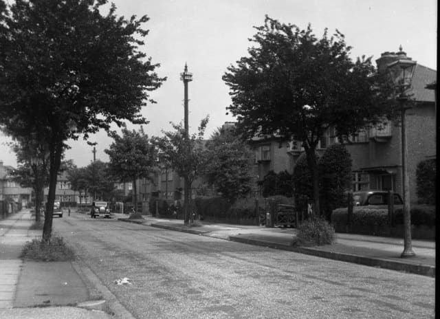
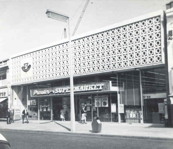
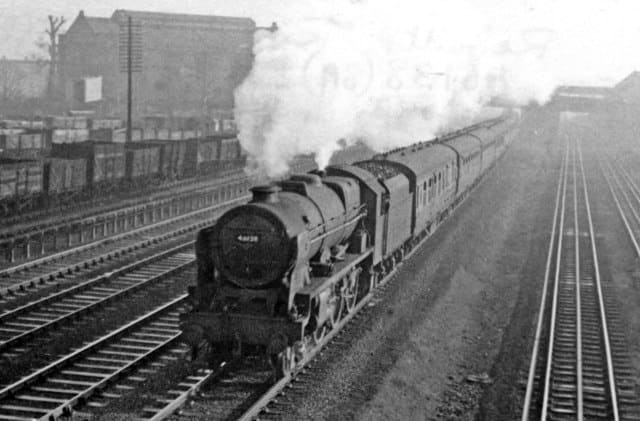
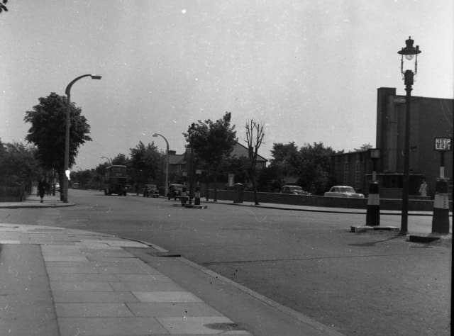

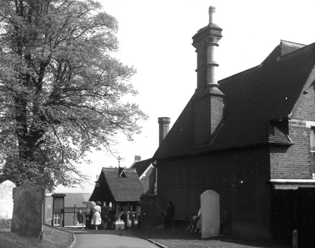
Updated 3 days ago · Geograph, Wikimedia Commons. Our copies are shared under the same licence as each photo: CC BY-SA 2.0.
Your councillorsCouncil servicesSpace to letAccessibilityPrivacyAsk Freddie, our AI assistant: bottom rightThis site uses cookies to count visits: Google Analytics counts the page and where you came from (privacy).